Rivers of India, origin, Length, and Tributaries: We all know the importance of rivers in our lives. The water of rivers is an invaluable natural heritage that is important for many human activities. India is a country where rivers are given the status of 'mother', in India rivers are considered very sacred and are worshipped.
In today's article, we will tell you about the rivers of India, their origin, length, tributaries, and drainage system.
Before knowing about the rivers of India, let us know what is the river?
'River is that fast-flowing stream which originates from a large glacier or reservoir etc. and flows in a definite path and gets absorbed in an ocean, sea, lake or another river.'
In some cases, a river flows into the ground and dries up at the end of its course without reaching another body of water. Rivers usually get their water from sources like glaciers, lakes, or rainwater.
Types of Rivers: There are mainly two types of rivers in India. These are as follows -
The source of water in perennial rivers (rivers of the Himalayas) is mainly glaciers.
Due to the melting of glaciers, the amount of water in these rivers is always maintained and during the rainy season the water level rises significantly and the rivers often get flooded.
The Peninsular rivers are seasonal, the source of water in them is usually rainwater. In the summer season, the water of these rivers decreases and starts flowing in small streams.
These types of rivers usually dry up in the summer season.
|
|
|
|
|
|
|
|
|
|
|
|
|
|
|
|
|
|
|
|
|
|
|
|
|
|
|
Let us know about the rivers of India, their origin, length, tributaries, and drainage system.
The river has a direction of its flow, which is called the drainage system. There are about 4000 small and big rivers in India. They can be mainly divided into two parts according to their drainage system.
The Himalayan drainage system includes the rivers originating from the Himalayas, which originate from the glaciers located in the Himalayas. The names of the rivers which are included in the Himalayan drainage system - are Indus, Ganga, Brahmaputra, Yamuna, Chambal, Betwa, Son, Gandak, Kosi, Ghaghra, Ken, Tons, etc.
The peninsular drainage system includes the rivers originating from the peninsular plateau and the rivers originating from the Western Ghats. The rivers of peninsular India either drain into the Bay of Bengal or into the Arabian Sea. The names of the rivers which are included in the peninsular drainage system - Mahanadi, Godavari, Krishna, Kaveri, Narmada, Tapti, Sabarmati, Mahi, Luni, Pennar, Vaigai, Damodar, Swarnrekha, Ghaggar, etc.
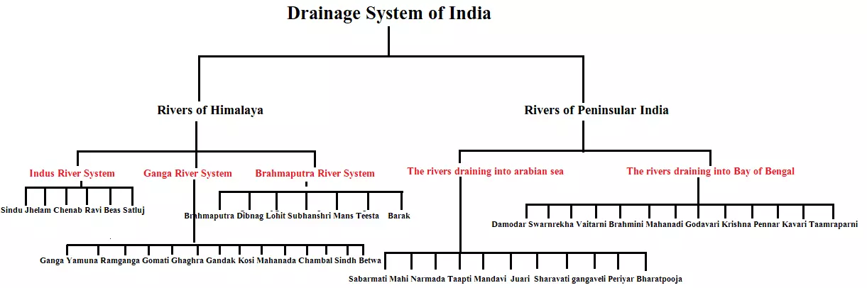 Himalayan Drainage System
The Himalayan drainage includes many river systems but the Indus, the Ganga and the Brahmaputra are the major river systems of Himalayan drainage.
These rivers of the Himalayas are also earlier than the Himalayas and even after the formation of the Himalayas they did not change their course and they cut the mountains in the Greater Himalayas and created deep valleys which are called gorges.
Some Gorge is as follows -
Apart from this, other rivers are Chambal, Ken, Betwa, and Son. Due to the rise of the Himalayas, the course of these rivers has been fixed and these rivers started flowing towards the east.
Some rivers started flowing from east to west from the south side of the Himalayas which joins the Indus river in Pakistan and drains its water into the Arabian Sea.
‘A river and its tributaries together make a river system.’
The Himalayan drainage system can be mainly divided into three river systems.
It is one of the largest river basins in the world. 'The Indus River originates in the Samokhyab Glacier located near Mansarovar in the Himalayas.'
It covers a total area of 11,65,000 km (in India it is 321,289 km) and has a total length of 2,880 km (1,114 km in India).
Indus flows through Jammu and Kashmir only in India.
The Indus also known as the Sindhu, is the westernmost of the Himalayan rivers in India.
After flowing in a northwest direction between the Ladakh and Zaskar ranges, it passes through Ladakh and Baltistan.
According to the Indus Water Agreement (1960) between India and Pakistan, India can use only 20% of the water of the Indus and its tributaries. We use the water of the Indus River for irrigation works in Punjab, Haryana, and Rajasthan.
The 5 major rivers of the Indus river system that flow in Punjab are called Panchanad.
Panchanad is the name given to five rivers of Punjab namely Sutlej, Beas, Ravi, Chenab, and Jhelum.
Sutlej River
The ‘Sutlej’ river rises in Tibet at an altitude of 4,555 meters from 'Rakshasa Tal' near Mansarovar, where it is known as Langchen Khambab. It passes through Shipki La on the Himalayan ranges and enters the plains of Punjab.
It is a very important tributary as it feeds the canal system of the Bhakra Nangal Project.
It is the antecedent river among the tributaries of the Indus.
Beas River
The ‘Beas’ river is a tributary of the Indus River but it does not discharge its water directly into the Indus River. It discharges its water in the Sutlej river. ‘Beas is a tributary of Sutlej.’ It enters the plains of Punjab where it joins the Sutlej near Harike.
Ravi River
The ‘Ravi’ is another tributary of the Indus river. It rises west of ‘Rohtang Pass’ in the Kullu hills of Himachal Pradesh and flows through the Chamba Valley of the state.
Chenab River
The ‘Chenab’ is the largest tributary of Indus.’ It is formed by two streams, Chandra and Bhaga, which join at Tandi near Keylong in Himachal Pradesh. It is called Chadrabhaga in Himachal.
Jhelum River
The ‘Jhelum’ is the only river in the Indus river system that originates from Jammu and Kashmir (from Sheshnag Lake near Berinag).
It flows through Srinagar and Wular Lake before entering Pakistan through a deep narrow valley. It joins the Chenab near Jhang in Pakistan. This river flows almost parallel to the border of India and Pakistan.
These five rivers join the Indus River near Mithankot, Pakistan, After this the Indus river flows towards the south and finally from Karachi towards the east, it falls into the Arabian Sea.
The main sequence of rivers coming from the left bank of the Indus is as follows - Jhelum, Chenab, Ravi, Beas, Sutlej
Some part of the Indus river is located in Jammu and Kashmir, Himachal Pradesh and Punjab while the remaining part is located in Pakistan.
Indus is joined by several Himalayan tributaries like Shyok, Gilgit, Zaskar, Hunza, Nubra, Shigar, Gasting, and Dras.
|
|
|
|
|
|
|
|
|
|
|
|
|
|
|
|
|
|
|
|
|
|
|
|
|
|
|
|
|
|
|
|
|
|
|
|
|
The Ganga river originates from the ‘Gangotri glacier’ near Gomukh in Uttarkashi district of Uttarakhand, where it is known as 'Bhagirathi'.
It flows first to the south, then to the south-east and east, and at last, it splits into two distributaries, namely the Bhagirathi and the Padma.
The total length of the Ganges River in India is 2,525 km. Its length is in Uttarakhand (110 km), in Uttar Pradesh (1,450 km), in Bihar (445 km), and in West Bengal (520 km).
The Ganges basin is spread over an area of about 8.6 lakh sq km in India alone.
The two main streams of the Ganges are Alaknanda and Bhagirathi.
At Devprayag, Bhagirathi meets Alaknanda; Thereafter, it is known as Ganga.
The Alaknanda River originates from the ‘Satopanth glacier’ above Badrinath and joins the Bhagirathi River at Devprayag.
The Alaknanda River is formed by the union of two streams - the Dhauli Ganga and the Vishnu Ganga. These two rivers meet at Vishnu Prayag or Joshimath and form the Alaknanda River.
The Pindar River joins the Alaknanda River at Karnprayag and the Mandakini River or Kali Ganga joins the Alaknanda at Rudraprayag.
Near Haridwar, the Ganges leaves the mountainous part and enter the plains. After this, many tributaries join it.
The Yamuna is the westernmost and longest tributary of the Ganges, which originates from the ‘Yamunotri glacier’ on the western slope of Bandarpoonch in Uttarkhand and flows parallel to the right bank of the river Ganges and joins the Ganges near Prayagraj.
|
|
Emerging from the peninsular plateau, coming from the south, the rivers joining the Ganges are Son, Betwa, Chambal, Sind, and Ken.
The Chambal, Sind, ken, and Betwa rivers do not mix directly with the Ganges and drain their water into the Yamuna.
Tons river joins the Ganges near Allahabad and the Son river joins the Ganges near Patna.
The Gomti River is the only tributary of the Ganges that originates in the plains, it originates from the ‘Fulhar Lake’ in the Pilibhit plain of Uttar Pradesh.
Ghaghra, Gandak, and Kosi enter India from Nepal and join the Ganges in Bihar.
Gandak river is called Narayani or Shaligram in Nepal. Every year due to these rivers, there is a flood in some parts of northern India and there is a heavy loss of life and property. But on the other hand, these rivers also provide fertile land for agriculture.
The Mahananda River is the easternmost and last tributary of the Ganges. It rises from the ‘Darjeeling hills’ in West Bengal.
|
|
After receiving water from the tributaries, the Ganges starts flowing in the east direction and flow till Farakka in West Bengal. Here this river splits into two parts - Bhagirathi and Hubli (Hubli river is the most treacherous river in the world). After this it flows south. and later falls into the Bay of Bengal, while its mainstream (Bhagirathi) flows south and enters Bangladesh, where it is known as 'Padma'. The Brahmaputra river, which is known as 'Jamuna' in Bangladesh, joins it.
Before falling into the Bay of Bengal, the combined stream of the Ganges and the Brahmaputra is known as 'Meghna'. Before falling into the sea, it splits into many smaller streams and forms a delta near the Bay of Bengal. Here is the world's largest delta which is called 'Sundarban Delta' is formed by the Ganges and the Brahmaputra river.
The extension of the Sundarban delta is from the Hubli river to the Meghna river and due to its fertile land, it is covered with forests. A tree named Sundari is found here, hence its name is Sundarban. Royal Bengal Tiger is also found here.
Ambala city is situated on the water divide between Indus and Ganges river systems.
|
|
|
|
|
|
|
|
|
|
|
|
|
|
|
|
|
|
|
|
|
|
|
|
|
|
|
|
|
|
|
|
|
|
|
|
|
|
|
|
|
|
|
|
|
|
|
|
|
|
|
|
|
|
|
|
|
|
|
|
The Brahmaputra River originates from the ‘Chemayungdung glacier’ of the Kailash range near the Mansarovar lake. In Tibet, it is known as the Tsangpo, which means ‘the purifier.’ It flows parallel to the Himalayas in the east. Its drainage system is widespread in China, India, and Bangladesh.
Reaching the Namcha Barwa mountain peak of India, it takes a U-shaped turn and enters the west of Sadiya town in Arunachal Pradesh through the gorge and here it is known as 'Dihang'.
After this tributaries like Dibang, Lohit, Kenula, etc. join it, and then it is known as the Brahmaputra in Assam. In Assam, many rivers like Manas, Dhanashree, Shubhanshri, Bhareli, etc. join it.
the Brahmaputra river in Assam has many Flows in streams and forms winding waterways. Here the Brahmaputra river forms many islands, out of which 'Majuli Island' is the world's largest river island [Manjuli is the only river district of India]. In Assam, it ramps up from Sadiya to Dhuvari.
From the Dhuvari coast, it flows westwards, and further from Goalpara, it enters Bangladesh. In Bangladesh, the Teesta joins its right bank from where the river is known as the ‘Jamuna’.
After this, 'Meghna River' which originates from the hills of Manipur and is called Barak, joins the Brahmaputra river near Bhairavbazar. It finally joins the Padma River, which drains into the Bay of Bengal. Its total length is about 2900 km.
|
|
The peninsular rivers are older than the Himalayan rivers and are in their mature state. These rivers have reached their bottom as they flow, so their flow has slowed down and they have become wide. Now their paths are fixed instead of winding.
There are two types of rivers in the peninsular drainage system -
|
|
The Mahanadi originates from Sihawa, located in Dhamtari district near Raipur, Chhattisgarh, and flows east and southeast and falls into the Bay of Bengal. It is 851 km long and its catchment area is spread over 1.42 lakh sq km.
53 percent of this river's drainage basin is in Madhya Pradesh and Chhattisgarh, while 47 percent is in Odisha. Before falling into the ocean, Mahanadi forms an important delta near Cuttack. There are multipurpose projects like Hirakud, Narar, Gangrel, and Rudri on Mahanadi.
Mahanadi is also called 'Ganga of Chhattisgarh State'.
The basin of Mahanadi in Chhattisgarh is called the 'Rice Bowl'.
|
|
The river Godavari originates from a hill in the village 'Tryambakam' located in the Western Ghats in the Nashik district of Maharashtra.
It is the longest peninsular river in India and the second-longest river in India after the Ganges.
Due to its large size and extent, it is called 'Dakshin Ganga'.
It is 1,465 km long in which the catchment area is spread over 3.13 lakh sq km.
49 percent of this is in Maharashtra, 20 percent in Madhya Pradesh and Chhattisgarh, and the rest in Andhra Pradesh.
This river is also suitable for boating. Shriram Sagar, Godavari Dam, Jayakwadi, etc. are some of the major dams on the Godavari River.
|
|
The Krishna River originates in the Western Ghats of Maharashtra near 'Mahabaleshwar' in Sahyadri.
Its total length is about 1400 km and it is the second-longest river in peninsular India.
27 percent of this is in Maharashtra, 44 percent in Karnataka, and 29 percent in Andhra Pradesh and Telangana. The Musi, the last tributary of the Krishna river, joins it near Wazirabad.
Some of the major dams built on Krishna and its tributaries are as follows:- Tungabhadra, Nagarjunasagar, Malaprabha, Bhima, Koyna, etc.
Rivers that join Krishna River from the left: Bhima, Mennur, Musi
|
|
The river Kaveri originates from the 'Brahmagiri hill' in Kogadu district of Karnataka. Its length is 800 km and it drains an area of 81,155 sq km.
It drains into the Bay of Bengal south of Cuddalore in Tamil Nadu.
About 3 percent of the Cauvery basin lies in Kerala, 41 percent in Karnataka, and 56 percent in Tamil Nadu.
The Kaveri river also forms the Cauvery delta near Tiruchirappalli and the Kaveri river forms the second largest waterfall in India, which is called 'Shivasamudram Falls'.
The Kaveri River is also called the 'Ganga of the South' because Water remains in it throughout the year, the reason for this is the water received from the southwest monsoon in Karnataka and the water received from the northeast monsoon in Tamil Nadu.
The valley of the Kaveri river is famous for paddy production, hence it is called the 'Rice Bowl of South India'.
|
|
The Pennar River originates from 'Nandidurga Hill' in the Kolar district of Karnataka. This river is situated between Krishna and Kaveri rivers.
The Vaigai River originates from the 'Varushnath Hill' in the Madurai district of Tamil Nadu. This river falls into Palk Bay. Madurai is situated on the banks of this river.
The Damodar River, Swarnrekha River and Brahmani River originate from the Chota Nagpur Plateau. Damodar river flows in the rift valley and sheds its water in Hubli. The Vaitarini River originates from the Kyojhar Plateau of Orissa.
The order of the rivers falling into the Bay of Bengal from north to south: Damodar, Swarnarekha, Vaitarni, Brahmani, Mahanadi, Godavari, Krishna Pennar, Kaveri, Baigai, Tamraparni.
All the above-mentioned rivers discharge their water in the Bay of Bengal.
|
|
The Narmada River originates from a place called 'Amarkantak' located in the Vidyanchal mountain range in the Anuppur district of Madhya Pradesh. This river flows 87% in Madhya Pradesh, 11.5% in Gujarat, and 11.5% in Maharashtra.
The total length of the Narmada river is 1312 km and its catchment area is about 98,796 sq. km.
The longest length of the Narmada river is in Madhya Pradesh. It is also known as the "Lifeline of Madhya Pradesh" due to its huge contribution to the state of Madhya Pradesh.
'The Narmada River is the longest river in peninsular India that drains its waters into the Arabian Sea.’
It flows in a rift valley between the Satpura in the south and the Vindhyan range in the north.
The Narmada river forms the 'Kapildhara or Dhundhar' waterfall in the marble rocks at Bhedaghat near Jabalpur.
Bargi Dam is a major dam located on the Narmada River near Jabalpur. Indira Sagar Project, Omkareshwar Multipurpose Project, Maheshwar Hydroelectric Project, Sardar Sarovar Project, etc. are located on the Narmada River.
The Narmada River discharges its water into the Gulf of Khambhat.
|
|
The Tapti River originates from the 'Multai to Satpura range' of Betul district of Madhya Pradesh.
It is 724 km long and drains an area of 65,145 sq km.
79% of this is in Maharashtra, 15% in Madhya Pradesh, and 6% in Gujarat. This river flows in the rift valley between Satpura and Ajanta.
The Tapi River is the second-longest river in peninsular India, draining its water in the Arabian Sea.
The Tapti River drains its water into the Gulf of Khambhat. Before it falls into the Gulf of Khambhat, Surat city is situated at its estuary.
Kakrapara and Ukai (Gujarat) project have been built on the Tapti River.
|
|
The Sabarmati River originates from the 'Aravalli mountain range' in the Udaipur district of Rajasthan.
The total length of the Sabarmati river is 371 km and the total catchment area is about 21,674 sq km.
The Dharoi Dam scheme is located on the Sabarmati river. Through this, the water of the Sabarmati river is used for irrigation and electricity generation in Gujarat.
Gandhi Ji established the Sabarmati Ashram on the banks of the Sabarmati River in Ahmedabad in 1915.
|
|
Mahi river originates from the 'Vidhyachal mountain range' of Minda village near the Dhar district of Madhya Pradesh.
The total length of the Mahi river is 576 km and the total catchment area is 34,842 sq km.
"Mahi river is the only river in India to cross the Tropic of Cancer twice."
Bajaj Sagar (Banswara) and Kadana Dam is built on the Mahi river.
|
|
The Luni River originates from the 'Nag Pahari' of Ajmer district near the Aravalli Mountains of Rajasthan.
The total length of the Luni River is 495 km.
Hemawas Dam, Sardar Samand Dam, Jawai Dam, Bankli Dam are the dams located on the Luni River.
The Luni river enters the Kutch district of Gujarat, and after that, it disappears in the 'Run of Kutch'.
The Luni River is highly saline and has been named 'Luni' because of its high salinity.
Apart from Jojdi, all other tributaries of Luni originate from Aravalli.
|
|
The Ghaggar River originates in the ‘Shivalik Hills’ of Himachal Pradesh near Shimla.
The Ghaggar River enters the Ganganagar of Rajasthan and empties into the Thar Desert.
The total length of the Ghaggar River is 456 km.
Rivers originating from the Western Ghats and drain into the Arabian Sea
Shatranji River, Madar River (Gujarat), Mandvi River (Goa's capital Panaji is situated on this river), Zuari River (Goa), Sharavati River (Jog Falls whose length is 271 meters, situated on this river), Gangaveli River (Karnataka), Bharathapuzha River (the longest river in Kerala), Periyar River (the second longest river in Kerala), Pamba River (Kerala).
|
|
In this article, we have given important information about the Rivers of India. This information about the rivers of India is very important from the exam point of view.
The questions related to this topic are asked in many exams. So we have tried to give you complete information about the rivers of India.
Hopefully, after reading this article completely, you must have increased your knowledge about the rivers of India.
Which is the longest river in India?
The Ganga is the longest river in India.
Which is the deepest river in India?
The Brahmaputra is the deepest river in India.
Which is the national river of India?
The Ganga is the national river of India
Which state is called the land of five rivers?
Punjab
Which river is called the Red river?
The Brahmaputra is known as the Red River in India.
Which river is called Sorrow of Bengal?
Damodar River is known as the Sorrow of Bengal
Which is the Salt river in India?
The Luni is the Salt River in India
Which river is also known as Sorrow of Bihar?
The Kosi River is known as the sorrow of Bihar.
Which river is known as the sorrow of Odisha?
Mahanadi river is known as the sorrow of Odisha.
Which river is known as "Sorrow of Assam"?
The Brahmaputra river is known as the sorrow of Assam.