In today's article, we will give you information about the Geography of India.
As you know how important this topic is from the exam point of view, our aim is to give complete information to everyone about Indian Geography.
Under this topic, we will tell you about the total population and area of India, total states and union territories of India, neighboring countries of India, coastal states of India, Tropic of Cancer in India, Indian Standard Time, the climate of India, seasons of India, and islands of India.
Folk Dance of India
So let's know the Geography of India.
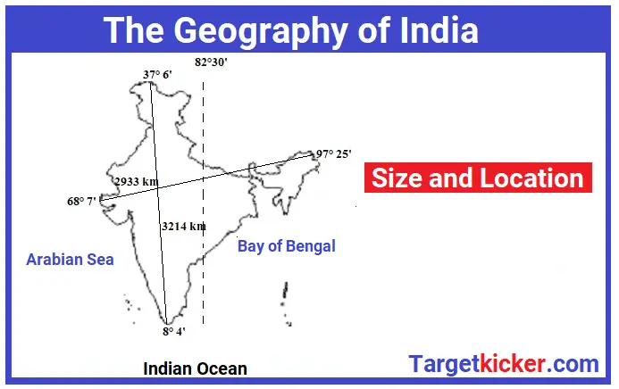
Geography of India -Size and Location
- Our country India is a country in South Asia located in the North-Eastern Hemisphere.
- On the one hand, are the great Himalayan ranges in the north, and on the other side is the vast Indian Ocean in the south.
- To the south of the Himalayas lies the flat plain formed by the Indus-Ganga-Brahmaputra and the tributaries to the north.
- The Desert is located in the western part of India. Various desert landforms are found in the desert. These are hot, dry, and sandy places.
- To the south of the northern plains lies the high and low and scattered Deccan plateau or peninsular plateau. Its shape is triangular.
- The Western Ghats (Sahyadri) is situated in the west of the peninsular plateau and the Eastern Ghats in the east.
- India also has great geographical diversity in terms of soil, vegetation, and natural resources.
Classical Dance of India
Physical Geography of India
- The geography of India is very diverse.
- Almost all types of landforms are found in the geographical structure of India.
- India can be divided into six geographical regions. Examples, The Great Mountains of the North, Northern Plains, Peninsular Plateaus, coastal Plains, The Desert, and Islands.
Location of India
- India is located in the Northern Hemisphere. India is the country of Asia Continents.
- The shape of India is quadrangular.
- Our country India is situated between 8° 4' N to 37° 6' N latitude and 68° 7' E to 97° 25' E longitude.
- Its extension from North to South i.e. from Ladakh to Kanyakumari is 3214 km and from East to West i.e. from Arunachal Pradesh to Kutch, its extension is 2933 km.
- The total border of India is 22,716.6 km.
- India has a land boundary of about 15,200 km (9,445 mi) and the total length of the coastline is 7,516.6 km (4,671 mi) while the length of the mainland coastline is 6,100 km.
- The northernmost point of India is Indira Call (Siachen Glacier) and the southernmost point is Indira Point or Pygmalion Point (Great Nicobar Island) and the easternmost point is Kibithu (Arunachal Pradesh) and the westernmost point is Gourmoti (Sirkrik, Gujarat).
- Cape Comorin, located in Kanyakumari, is the southernmost point of the mainland of India.
- The northernmost point Indira Call was named by its discoverer Bull Workman in 1912 after Indira, a name for the Indian goddess Lakshmi, and has no relation to Indira Gandhi.
- India is surrounded by the Arabian Sea in the west, the Lakshadweep Sea in the south-west, the Bay of Bengal in the east, and the Indian Ocean in the south.
- The territorial waters of India extend to a distance of 12 nautical miles (13.8 mi; 22.2 km) from the coast.
What is Time Zone and why it is different in different countries?
The current population of India
- The current population of India is 1.3 billion which is about 17.7% of the total population of the world.
- India is the second-largest country in the world after China in terms of population.
- The 5 largest countries after India in terms of population are the USA, Indonesia, Pakistan, Brazil, and Bangladesh.
Total Area of India
- The area of India is 32,87,263 sq km which is 2.42% of the total area of the world.
- India is the seventh-largest country in the world in terms of area.
- Countries larger than India in the area are as follows - Russia, Canada, the USA, China, Brazil, and Australia.
- The largest state of India in terms of population is Uttar Pradesh (about 20 crores).
- The smallest state in India in terms of population is Sikkim (5,40,493).
- The largest state of India in terms of area is Rajasthan (342,239 sq km).
- The smallest state in India in terms of area is Goa (3,702 sq km).
- The largest union territory of India in terms of population is Delhi
(16,787,941).
- The smallest union territory of India in terms of population is Lakshadweep (64,473).
- Ladakh (59,146 sq km) is the largest union territory of India in terms of area.
- The smallest union territory of India in terms of area is Lakshadweep (32 sq km).
The Origin of the Mahajanapadas
Political Geography of India
Total states and union territories
- The Indian state of Uttar Pradesh shares a border with most states.
- It is bounded by Uttarakhand and Himachal Pradesh in the north, Haryana, Delhi, and Rajasthan in the west, Madhya Pradesh and Chhattisgarh in the south, and Bihar and Jharkhand in the east.
Neighboring Countries of India
- India shares its border with a total of 11 countries. This includes the land border and water border.
- India shares land borders with a total of 7 countries.
- India shares a land border with Pakistan and Afghanistan to the west, China, Nepal, and Bhutan to the northeast, and Bangladesh and Myanmar to the east.
- India shares a water border with 4 countries.
- India shares a water border with the Maldives in the southwest, Sri Lanka in the south, and Indonesia and Thailand in the southeast.
- The Palk Strait and the Gulf of Mannar separate India from Sri Lanka in the southeast.
- The Maldives is connected to the Lakshadweep Islands of India by the Eight Degree Channel.
- India's Andaman and the Nicobar Islands, about 1,200 kilometers (750 mi) southeast of the mainland, share maritime borders with Myanmar, Thailand, and Indonesia.
The List of Indian Prime Minister
Tropic of Cancer in India
The Tropic of Cancer (23° 30'N) divides the country into almost two equal parts i.e Nothern India and Southern India.
Tropic of Cancer passes through eight states of India. These eight states are:
- Gujarat,
- Rajasthan,
- Madhya Pradesh,
- Chhattisgarh,
- Jharkhand,
- West Bengal,
- Tripura and
- Mizoram (order from west to east)
Top 10 Highest Mountains in the world
Coastal States of India
India has 9 coastline states and 4 union territories.
The coastal length of mainland India is 6100 km and the total coastal length including islands is 7516.6 km.
9 coastline states of India are -
- Gujarat (1214.6 km),
- Maharashtra (720 km),
- Goa (101 km),
- Karnataka (300 km),
- Kerala (550 km),
- Tamil Nadu (980 km),
- Andhra Pradesh (970 km),
- Orissa (484 km),
- West Bengal (210 km)
4 Coastal Union Territories
- Andaman And Nicobar
- Lakshadweep
- Puducherry
- Daman Island
The state with the longest coastline in India is Gujarat (1214.6 km) while the Union Territory with the longest coastline is Andaman and Nicobar Islands.
What is Earth
Indian Standard Time
The standard meridian (82°30' East longitude) of India passing through Mirzapur, Uttar Pradesh is considered the standard time for the whole country. This is called the IST (Indian Standard Time) line.
India's standard meridian is 82.5° East of Greenwich, which means our Standard Time is 5:30 hours ahead of Greenwich Standard Time (GMT).
Indian states falling on the standard meridian line are - Uttar Pradesh, Madhya Pradesh, Chhattisgarh, Orissa, and Andhra Pradesh.
What are the layers of the earth?
The Climate of India
The Indian climate is very diverse.
The monsoon winds coming from the Indian Ocean located in the south of India have the greatest effect on the climate of India. That is why the climate of India is called 'Tropical Monsoon Climate'.
The climate of India is tropical in the south and alpine (polar-like) in the Himalayan regions due to the high altitude, it is tropical moist type in Northeast India and dry type in western parts.
Seasons of India
According to the ‘Indian Meteorological Department’, there are four types of seasons in India.
- Winters Season - From December to March, the average temperature in northern India is 10 to 15 °C.
- Summer or pre-monsoon Season- From April to June, the average temperature is 32 to 40 °C.
- Monsoon or Rainy Season - From July to September
- Autumn or Post-monsoon Season - From October to November
The Island of India
The islands of India are divided into two parts:
- Andaman and Nicobar Islands located in the Arabian Sea and
- The 'Lakshadweep Islands are located in the Bay of Bengal.
- 'Andaman and Nicobar Islands is located in the south-east direction of India.
- The 'Lakshadweep Islands' is a coral island located some distance off the coast of Kerala.
- The capital of 'Andaman and Nicobar' is 'Port Blair'.
- The capital of 'Lakshadweep' is 'Kavaratti'.
- India's only active volcano 'Barren Island' is located in the Nicobar Islands.
All Country Currency
Conclusion
In today's article, we have tried to give you much important information about the Geography of India.
Hope you liked the information given by us.
FAQ’s
|
How many geographical features are there in India?
There are 6 Geographical features in India. The Great Mountains of the North, Northern Plains, Peninsular Plateaus, coastal Plains, The Desert, and Islands.
|
|
In which hemisphere India is located?
India is located in the Northern-Eastern Hemisphere.
|
|
India is a part of which continent?
India is a part of the Asia Continent.
|
|
Which is the oldest part of India?
The Peninsular Plateau is the oldest landmass of the Indian subcontinent.
|
|
How many states are in India?
There are 28 states in India.
|
Read this Also
