There are an infinite variety of landforms on the earth. But the Major landforms of the earth are - Mountains, Hills, Plateaus, and Plains.
In this article, we will learn about these major landforms of the earth. We will discuss - What is Mountain, Types of Mountains, What is Hill, What is Plateau, Types of Plateau, What is Plain, How are Plain formed, Types of Plains.
We will learn all the above topics in this article one by one. So let's start our topic - The Major Landform of the Earth.
A mountain is a naturally elevated landform on the earth's surface. The tip of the mountain is small and the base is wide. The mountain is much higher than its surrounding area. The height of the mountains should be 600 meters higher than the level of the earth. The Mountain extends over 26% of the total surface area.
There are four types of Mountains -
Volcanic mountains
Fold mountains
Block mountain
Residual mountain
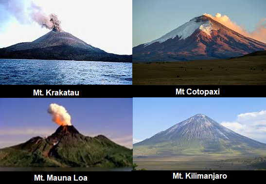
Volcanic Mountains: Mountains that are formed by collecting Magma in the shapes of cones in a place, are called Volcanic mountains. Volcanic Mountains are called Mountains of accumulation.
Example of Volcanic Mountain: Mt. Mauna Loa (Hawaii), Mt. Vesuvius (Italy), Mt. Kilimanjaro (Africa ), Mt. Mount Fujiyama (Japan), Mt. Krakatau (Indonesia), Mt Cotopaxi (Ecuador).
Fold Mountains: When tectonic plates collide with each other inside the earth, one plate comes on the other plate and thus the upper plate takes the shape of a mountain and the other plate is plunged down, such mountains are called Fold Mountains.
Example of Fold Mountains: New Fold Mountains - The Himalayas (Asia), The Andes (South America), The Rockies (North America), The Alps (Europe).
Old Fold Mountains: The Aravali Range (India), The Appalachian (North America), and The Ural Mountains (Russia).

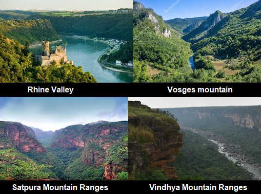
Block Mountains: Block mountains are formed when a large area of the earth is broken vertically or horizontally and displaced. The uplifted blocks are called horsts, and the lowered blocks are called graben, the mountain thus formed is called a Block Mountain.
Example of Block Mountains: Rhine Valley and the Vosges mountain (Europe), Mountain ranges of Satpura and Vindhya (central-western part of the Indian subcontinent), Sierra Nevada (California), Black Forest Mountains (Europe).
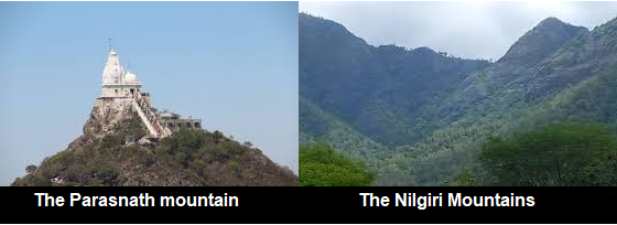
Residual Mountains: Mountains that are formed as a result of erosion of rocks are called Residual Mountain.
Example of Residual Mountain: The Aravalli Mountain, The Parasnath mountain ( Bihar), Eastern Ghats and the Western Ghats, the Nilgiri Mountains(Tamilnadu), Rajmahal Hills.
|
Name |
Location |
Height |
|
Mount Everest |
Nepal/China |
29,029ft (8,848m) |
|
K2 |
Pakistan |
28,251ft (8,611m) |
|
Kangchenjunga |
Nepal/India |
28,169ft (8,586m) |
|
Lhotse |
Nepal/China |
27,940ft (8,516m) |
|
Makalu |
Nepal/China |
27,838ft (8,485m) |
|
Mountain |
Continent |
Location |
Height |
|
Mount Everest |
Asia |
Nepal/China |
29,029 feet (8,848 meters) |
|
Mount Kilimanjaro |
Africa |
Tanzania |
19,341 feet (5,895 meters) |
|
Denali |
North America |
Alaska (USA) |
20,310 feet (6,190 meters) |
|
Mount Aconcagua |
South America |
Argentina |
22,837 feet (almost 6,961 meters) |
|
Mount Elbrus |
Europe |
Russia |
18,510 feet (5,642 meters) |
|
Mount Kosciuszko/Puncak Jaya |
Australia |
New South Wales (Australia) |
7,310 feet (2,228 meters) |
|
Mount Vinson |
Antarctica |
Palmer Peninsula in western Antarctica. |
16,050 feet (4,892 meters) |
|
Note: The Highest Mountain in the World - Mount Everest (8,850 m (29,035 ft)) Mauna Kea (Hawaii) is an undersea mountain in the pacific ocean. It is higher than Mount Everest. The height of Mauna Kea Mountain is 10205 m. |
The Mountain is bigger than the Hill. Mountains that are less than 300 meters in height are called Hills. The Hills are higher than the surrounding plains. The regional expansion of the Hill is less. The Hills are formed by soil deposited by glaciers, erosion of mountains, friction, breakage, explosion, etc. The Hills are often piles of soil or rocks. The slopes of the hills are not very steep and the summits of the Hills are often circular.
The highest hill in the world is Cavanal Hill in Oklahoma, which is 2000 feet high.
A Plateau is an elevated flat land. The upper part of the plateau is wide and flat like a table. One or both sides of the plateau are like a steep slope. Plateau is also called high plains or tablelands. The Plateau extends over 33% of the total surface area. The elevation of the Plateau is up to 600 meters above sea level.
There are five types of Plateaus -
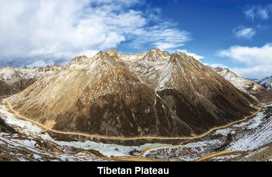
Intermontane Plateaus: Plateaus that are partially or completely surrounded by mountain ranges are called Intermontane Plateaus. Intermontane plateaus are the highest Plateau in the world.
Example of Intermontane Plateaus: Tibetan Plateau (surrounded by the Kunlun Mountains in the north and the Himalayas in the south.), Plateau of Mongolia, the Bolivian plateaus, the Western United States, Mexican Plateau, Asia Minar Peru.
Piedmont Plateaus: The Plateaus on which the mountain is situated on one side and a plain or sea/ocean on the other side are called the Piedmont Plateaus.
Examples of Piedmont Plateaus: Appalachian Mountains (USA) and Patagonian plateau (Argentina), Shillong Plateau of India, Piedmont Plateau (USA), Malwa plateau.

Continental Plateaus: The Plateaus which cover the original topography completely either by a broad continental uplift or by the propagation of a horizontal basic lava sheet, are called Continental Plateaus.
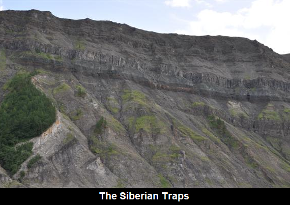
Example of Continental Plateaus: Plateau of Australia, Arab Plateau, Siberian shield.
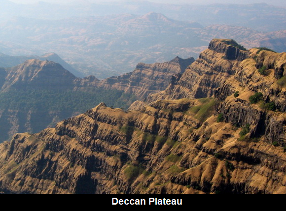
Volcanic Plateaus: Plateaus that are formed by volcanic activity, are called Volcanic plateaus.
Example of Volcanic Plateaus: Columbia Plateau (USA), Deccan Plateau of India.
Domed Plateaus: A Domed Plateaus forms as a result of the slow collision of tectonic plates' movement in the Earth’s crust. Their middle part rises up and the edges become round.
Example of Domed Plateaus: Plateau of Ozark (U.S.A.), Chota Nagpur plateau of Jharkhand.

|
Note: The Deccan plateau in India is one of the oldest plateaus. Tibet Plateau is the highest plateau in the world. The height of the Tibet plateau is 4000 - 600 meters above the mean sea level. |
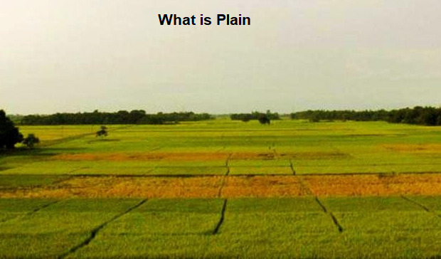
Generally, the plain and broad terrain, 200 m above sea level is called the Plain. The level of some plains is extremely high and some may even be below sea level. Such as the Great Plains of North America, which is higher than its adjacent Alpsian Mountains, and on the other hand, the Jordan Valley and Holland's Polder Plains are also found below sea level. The Plain extends over 41% of the total surface area. Plains are the most important landforms.
The plains are called the 'cradle of civilization'.
Many plains are formed by deposits of sediments brought down by rivers. When the rivers reach their valley, their flow decreases, so the deposits of sediments (stones, mud, silt) brought along with the river gather at that place. And this creates the Plain.
Besides rivers, some plains are also formed by the activity of air, glaciers, and tectonic activities.
There are three types of Plains -
Depositional plains
Erosional plains
Structural plains
Erosional plains - Continuous and prolonged erosion of all types of upland creates Erosional Plains. The surface of such plains is rarely smooth. Hence they are also called Peneplanes which means almost a plain.
Erosional plains Example: Such as Northern Canada, Northern Europe, Western Serbia, Canadian shield and the West Siberian plain, Niagara Plains in the USA, and the Lorrain in France.
Types of Erosional Plain -
Loess Maidan - Plains made of particles of soil and sand, blown by the wind.
Example: Losses of China, Europe, USSR, lower Mississippi (USA), Rhine valley (Alsace), southern Netherlands.
Karst Plains - Plains formed by dissolving limestone rocks.
Example: Karst region of Yugoslavia
Sampray Maidan - Plains located near the sea level, which is formed due to erosion of rivers.
Glacier Plains - Plains formed due to snow accumulation, where only forests are found.
Example: Kashmir in India, the northern part of North America, and Northwestern Eurasia.
Desert plain - It is formed as a result of rivers flowing due to rain.
Example: Gobi Desert, Sahara Desert.
Depositional Plains: Depositional Plains are formed by the deposition of materials brought by various agents of transport such as rivers, wind, waves, and glaciers.
Depositional Plains Examples: Gangetic-Brahmaputra Plain (North India), Hwang (China), the plains of Ganga, Sutlej, Misi-Sipi, and Hwang Ho.
Structural plains: Structural plains are mainly formed by the uplift of a part of the sea level. The endogenic force of the earth forms these types of plains. These extensive lowlands are bordering all major continents.
Structural Plains Examples: Coromandel, Malabar Coastal plain, and the Northern Government (India), Great Siberian Plain, Great Plain of USA, Coastal Plain of Belgium.
