Today's article is very important. You are going to get very important information in this article, which will be very useful for you in many competitive exams.
You all must have read or heard about strait, isthmus, island, peninsula, gulf, and pass, etc. many times, but these will always create confusion in your mind.
In this article, you will learn about these important geographical terms. You will learn what is Strait, what is Isthmus, the difference between Strait and Isthmus, what is Island, what is Peninsula, what is Gulf, and what is a pass.
In this article, you will learn about all these in a very easy language. And we will also know in detail the other important facts related to them.
After reading this article, all your doubts about strait, isthmus, island, peninsula, gulf, and pass will be cleared. We will learn about all these in detail one by one. So let's start our article -
Narrow waterways connect two large bodies, such as the sea or the ocean, and through which ships or boats can travel from one large reservoir to another. They are called Strait. Talking about its geographical size, it is often like a dammer, and there is a strait in the middle of its two large aquatic parts, so it is also called a strait. Strait also separates two large landmasses.
|
List of Straits |
||
|
Strait |
Landmass |
Connecting Water Bodies |
|
Malacca Strait |
Indonesia-Malaysia |
The Andaman Sea & South China Sea |
|
Hormuz Strait |
Iran and Oman |
The Gulf of Oman and the Persian Gulf |
|
Bab-el-Mandeb |
Djibouti, Yemen, and Eritrea of the Somali Peninsula |
The Gulf of Aden and the Red Sea |
|
Ten Degree Channel |
Car Nicobar Islands and Little Andaman |
The Andaman Sea and the Bay of Bengal |
|
Sunda Strait |
Java island of Indonesia with its Sumatra island. |
The Java Sea and the Indian Ocean |
|
Florida Strait |
Cuba and the USA |
Gulf of Mexico and the Atlantic Ocean |
|
Bering Strait |
Asia from America |
The Arctic Ocean and East Pacific ocean |
|
Strait of Gibraltar |
Spain and Morocco |
The Atlantic Ocean and the Mediterranean Sea |
|
Korea Strait |
Japan and South Korea |
The East China Sea and the Sea of Japan |
|
Bonifacio Strait |
Corsica island of France and Sardinia islands of Italy |
The Tyrrhenian Sea and the Mediterranean Sea |
|
Palk Strait |
India and Sri Lanka |
The Bay of Bengal in the northeast with the Palk Bay/Arabian Sea in the southwest |
|
Bosphorus Strait |
Divides Europe from Asia |
The Black Sea to Sea of Marmara |
|
Bass Strait |
Tasmania island and mainland Australia |
The Great Australian Bight and the Tasman Sea |
|
Davis Strait |
Between Greenland and Canada |
The Baffin Bay and the Labrador Sea |
|
Jamaica Channel |
Jamaica and Hispaniola |
The Caribbean Sea and North Atlantic |
|
Nemuro strait |
Kuril Island, Russia Hokkaido, Japan |
|
|
North Channel |
Ireland-England |
The Irish Sea & Atlantic Ocean |
|
Cook Strait |
Italy-Albania |
The Adriatic Sea & Ionian Sea |
|
Mozambique Strait |
Mozambique -Madagascar |
Indian Ocean |
|
Hudson strait |
Canada |
Gulf of Hudson & Atlantic Ocean |
|
Messina Strait |
Italy-Sicily |
Mediterranean Sea |
|
Magellan strait |
Chile |
Pacific and South Atlantic Ocean |
|
Makassar Strait |
The Java Sea & Celebes Sea |
Indonesia |
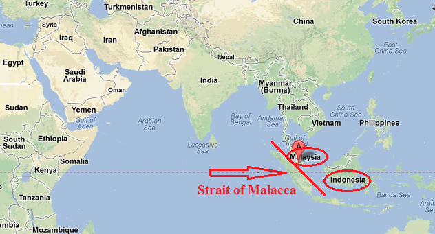
The longest straits in the world
The Straits of Malacca is 890 km (550 mi) long, is the longest strait in the world. It is located between the Malay Peninsula (Peninsular Malaysia) and the Indonesian island of Sumatra. It connects the Andaman sea (Indian ocean) with the south china sea (pacific ocean). The straits of Malacca is one of the most important shipping lanes in the world.
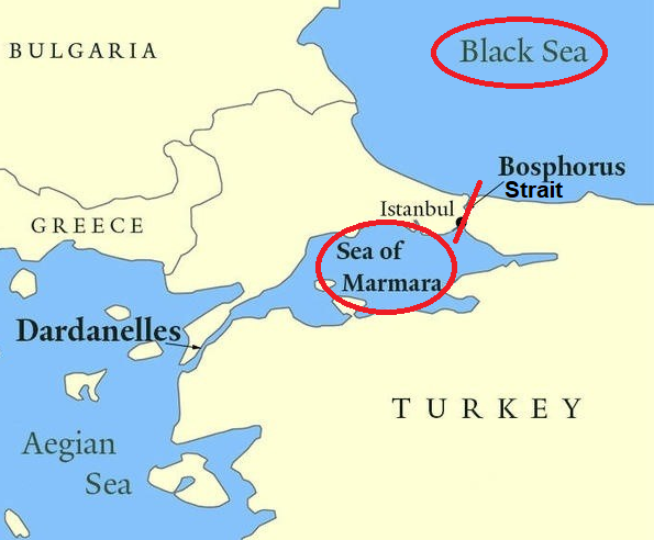
The narrowest strait in the world
Bosporus strait is the narrowest strait in the world. Bosporus strait connects the Black Sea with the Sea of Marmara. It is located in northwestern Turkey. The Bosporus strait is 19 miles (30 km) long. It is also known as the Strait of Istanbul. The Bosphorus strait divides Europe and Asia Continents.
A narrow piece of land that connects two large landmasses and separates two large bodies of water is called an Isthmus.
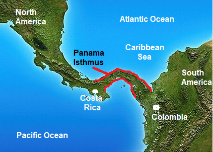
Largest isthmus in the world
Isthmus of Panama
It lies between the Caribbean Sea and the Pacific Ocean which links North and South America. Panama Isthmus separates the Atlantic and Pacific Oceans.
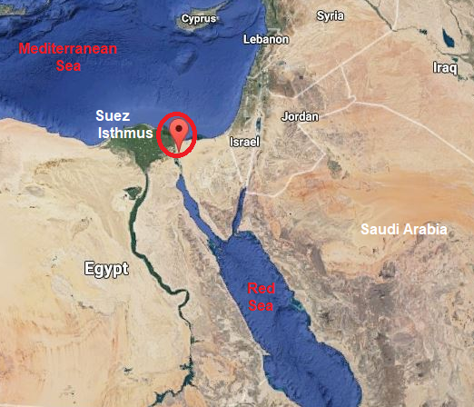
Suez Isthmus
Suez's Isthmus, located in eastern Egypt, separates the Mediterranean and Red Seas and connects the continents of Africa and Asia. The Suez isthmus is 75-mile-wide (125-km) long. The Isthmus of Suez is particularly notable because of the presence of the Suez Canal.
A Peninsula is a landform surrounded by water on three sides, while it is connected to a mainland from which it extends.
The peninsula can be very large. Florida is a peninsula that separates the Gulf of Mexico and the Atlantic Ocean.
Peninsula Examples
Largest Peninsula in the World
The Largest Peninsula in the World is the Arabian. It is surrounded on three sides by the Gulf of Aden in the south, the Arabian Sea in the southeast, the Persian Gulf in the northeast, and the Red Sea in the west.
It is located in the middle east. The peninsula contains seven nation-states: Saudi Arabia, the United Arab Emirates, Oman, Yemen, Kuwait, Bahrain, and Qatar.
The Arabian Peninsula plays a large role in oil and gas extraction and refining.

Deccan Peninsula
Deccan Peninsula is the second largest peninsula in the world. is located in the southern part of central India. It is surrounded on three sides by the Arabian Sea in the West, the Bay of Bengal in the East, and the Indian Ocean in the South.
The peninsula is the largest in the world by a number of inhabitants.

Indochina Peninsula
The Indochina Peninsula is a part of southeast Asia.
The peninsula comprises countries - Cambodia, Laos, Myanmar, Thailand, and Vietnam.
The Indochina Peninsula has the Andaman Sea to the west, the Malacca Strait to the southwest, and the China Sea to the east.
|
Largest Peninsula in the world list |
|||
|
Name of Peninsula |
Area (SqKm) |
Bordering Seas |
Countries |
|
Arabian |
3,237,500 |
The Persian Gulf, Gulf of Oman, Arabian Sea, Gulf of Aden, Red Sea |
Bahrain, Kuwait, Oman, Qatar, Saudi Arabia, UAE, Yemen |
|
Indian (Deccan) Peninsula |
2,072,000 |
Arabian Sea, Indian Ocean, Bay of Bengal |
South India |
|
Indo-china Peninsula |
1,938,743 |
China Sea, Bay of Bengal, Malacca Strait, Indian Ocean |
Cambodia, Laos, Myanmar, Thailand, Vietnam |
|
Horn of Africa (Somali Peninsula) |
1,882,857 |
Gulf of Aden, Arabian Sea |
Djibouti, Eritrea, Ethiopia, Somalia |
|
Alaska Peninsula |
1,500,000 |
Pacific Ocean, Bering Sea |
United States |
|
Labrador Peninsula |
1,400,000 |
Hudson Bay, Labrador Sea, Gulf of Saint Lawrence, Atlantic Ocean |
Canada |
|
Scandinavian Peninsula |
750,000 |
Baltic Sea, North Sea, Norwegian Sea |
Norway, Sweden, north Finland |
|
Balkan Peninsula |
666,700 |
Adriatic Sea, Ionian Sea, Mediterranean Sea, Aegean Sea, Black Sea |
Albania, Bosnia & Herzegovina, Bulgaria, Croatia, Greece, Kosovo, Macedonia, Montenegro, Romania, Serbia, Slovenia, North Turkey |
|
Iberian Peninsula |
582,000 |
Atlantic Ocean, Mediterranean Sea |
Andora, Portugal, Spain, France |
|
Korean Peninsula |
220,847 |
East China Sea, Yellow Sea, Korean Strait |
North Korea, South Korea |
|
Florida Peninsula |
170,304 |
The Gulf of Mexico, Florida Strait, Atlantic Ocean |
United States (Florida State) |
|
Baja California Peninsula |
143,390 |
The Pacific Ocean, Gulf of California |
Mexico |
|
Italian Peninsula |
131,337 |
Adriatic Sea, Ionian Sea, Tyrrhenian Sea, Mediterranean Sea |
Italy, San Marino, Vatican City |
|
Kola Peninsula |
100,000 |
Barents Sea, White Sea |
Russia |
|
Sinai Peninsula |
60,000 |
Suez Canal, Gulf of Aqaba, Red Sea, Mediterranean Sea |
Egypt |
|
Crimean Peninsula |
27,000 |
The Black Sea, Sea of Azov |
Ukraine (now Russia) |
The parts of the landmass around which the expansion of water is found are called Islands. Islands can be small and large in size. They range in size from a few square meters to thousands of square kilometers.
When many islands are found in one place in the sea, they are called archipelago. Andaman, Lakshadweep, etc. are examples of archipelago in India.
There are a total of 247 islands in India of which 204 islands are located in the Bay of Bengal.
Largest Island in the world
Greenland is the largest island in the world. Greenland lies between the Arctic Ocean and the North Atlantic Ocean, and to the northeast of Canada and northwest of Iceland.

Smallest Island in the world
Bishop rock is the smallest island in the world. It is part of the Isles of Scilly in the United Kingdom.
Bishop Rock is a rock off the British coast in the North Atlantic Ocean known for its lighthouse. The height of the Tower is 49 meters (161 ft).
It is in the westernmost part of the archipelago, 45 km (28 mi) from the southwest tip of the Cornish peninsula of Great Britain.
|
List of Island of the world |
||
|
Island |
The area in Square kilometers |
Location |
|
Greenland |
2,130,800 square kilometres(822,700 square miles) |
Between the Atlantic and Arctic Oceans (Demark) |
|
New Guinea |
785,753 square kilometers (303,381 square miles) |
Southwest Pacific (Indonesia) |
|
Borneo |
748,168 square kilometers (288,869 square miles)
|
West mid-Pacific Ocean (comprises three countries, namely Indonesia, Malaysia, and Brunei) |
|
Madagascar |
587,041 square kilometers (226,658 square miles)
|
East coast of Africa, in the Indian Ocean (Madagascar) |
|
Baffin |
507,451 square kilometers (195,928 square miles) |
North Atlantic (The largest island of Canada) |
|
Sumatra |
443,065 square kilometers (171,068 square miles) |
West of Java and south of the Malay Peninsula in the northeast Indian Ocean (Indonesia) |
|
Honshu |
225,800 square kilometers (87,200 square miles)
|
Between the Pacific Ocean and the Sea of Japan (Japan) |
|
Victoria |
217,291 square kilometers (83,897 square miles) |
Arctic Ocean (Canada) |
|
Great Britain |
209,331 square kilometers (80,823 square miles) |
Northwest of the European continent (The biggest island in Europe) |
|
Ellesmere
|
196,236 square kilometers (75,767 square miles)
|
Arctic Ocean (Canada) |
The sea area surrounded by land on three sides and around which a lot of lands is surrounded is called the Gulf.
The Gulf almost looks as the ocean has taken a bite out of the coast. These bodies of water are usually deep and large.
The bay is usually named after the countries or cities, it is surrounded by.
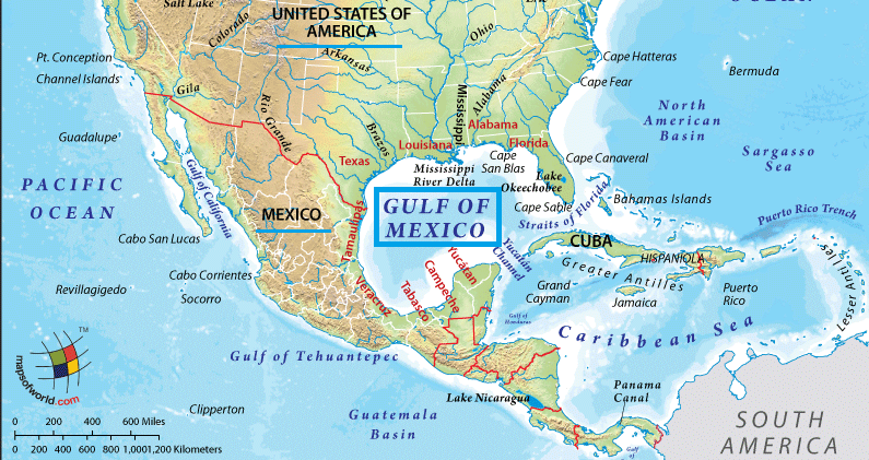
Gulf of Mexico
The Gulf of Mexico is the largest gulf in the world. It borders Mexico, Cuba, and five states in the United States. It is largely surrounded by the North American continent. The Gulf of Mexico has formed about 300 million years ago as a result of plate tectonics. The area of gulf Mexico is 61500 sq miles.
Gulf of California
The Gulf of California is the smallest gulf in the world. The Gulf of California, also known as the Sea of Cortez. The Gulf of California separates the Baja California Peninsula from the Mexican mainland. Parts of the Gulf of California are UNESCO World Heritage Sites.

The wide narrow and natural transport route found in the middle of the mountains through which the mountains can be crossed is called the Pass.
Highest mountain pass in the world
Umling La is the highest motorable pass in the world at 5,882 m (19,300 feet). It connects Chisum and Demchok villages. It is located in the Ladakh region of Jammu and Kashmir. It is about 235 km from Leh.
Earlier Khardung La mountain pass was considered to be the world’s highest mountain pass. Khardung La is a mountain pass in the Leh district of the Indian union territory of Ladakh.
|
List of Mountain Passes in India |
|
|
Pass |
Location |
|
Nathu La Pass |
Sikkim (It connects the Indian state of Sikkim to the Tibet Autonomous Region of China) |
|
Shipki La Pass |
Himachal Pradesh (It connects Shimla to Tibet) |
|
Jelep La Pass |
Sikkim. |
|
Khardung La |
Ladakh |
|
Thang La / Taglang La |
Ladakh |
|
Chang-La |
Ladakh |
|
Bara-La/ Bara- Lacha La |
Jammu and Kashmir (It connects Manali and Leh). |
|
Mana Pass: Uttarakhand-Tibet |
Greater Himalayas (It connects Tibet with Uttarakhand) |
|
Niti Pass |
Uttarakhand (It connects Uttarakhand with Tibet) |
|
Rohtang Pass: |
Himachal Pradesh (It connects Kullu, Spiti, and Lahaul) |
|
Bomdi-La: Arunachal Pradesh-Lhasa |
Arunachal Pradesh (It connects Arunachal Pradesh with Lhasa, the capital city of Tibet) |
|
Dihang pass: |
Arunachal Pradesh (It connects Arunachal Pradesh with Myanmar (Mandalay)) |
|
Diphu pass: |
Arunachal Pradesh (This pass disputed the tripoint borders of India, China, and Myanmar) |
|
Pangsau Pass |
Arunachal Pradesh (It connects Arunachal Pradesh and Myanmar)
|
|
Banihal Pass |
Jammu and Kashmir (It is situated in the Pir- Panjal Range. It connects Banihal with Qazigund) |
|
Zoji La |
Jammu Kashmir (It connects Srinagar with Kargil and Leh) |
|
Burzil pass |
Jammu Kashmir (It connects Astore Valley of Kashmir with the Deosai Plains of Ladakh) |
|
Pir-Panjal Pass |
Jammu Kashmir (It connects Jammu to Srinagar) |
|
Bhor Ghat |
|
|
Thal Ghat |
|
|
Pal Ghat |
The mountain pass is located between Nilgiri Hills (Tamil Nadu) in the north and Anaimalai Hills (Kerala) |
